|
Location
Gyaur qala is situated 63km from Biruniy and 81km from No'kis. It is located just 80 metres from the right bank of the Amu Darya and 1.5km west of the
Sultan Uvays Dag mountains. It falls within the Qarao'zek tuman of Karakalpakstan.
To avoid confusion with the Gyaur qala fort at Mizdahkan it is sometimes clumsily referred to as Gyaur qala Sultan Uvays Dag.
To reach the site from Biruniy, leave the city on the A380 heading for No'kis. The road turns towards the north after leaving the Biruniy urban area,
heading for the mountains. After 34km, close to the mountains, the direction of the road turns towards the east and after 50.5km it reaches the left
turn for the Badai Tugai Reserve.
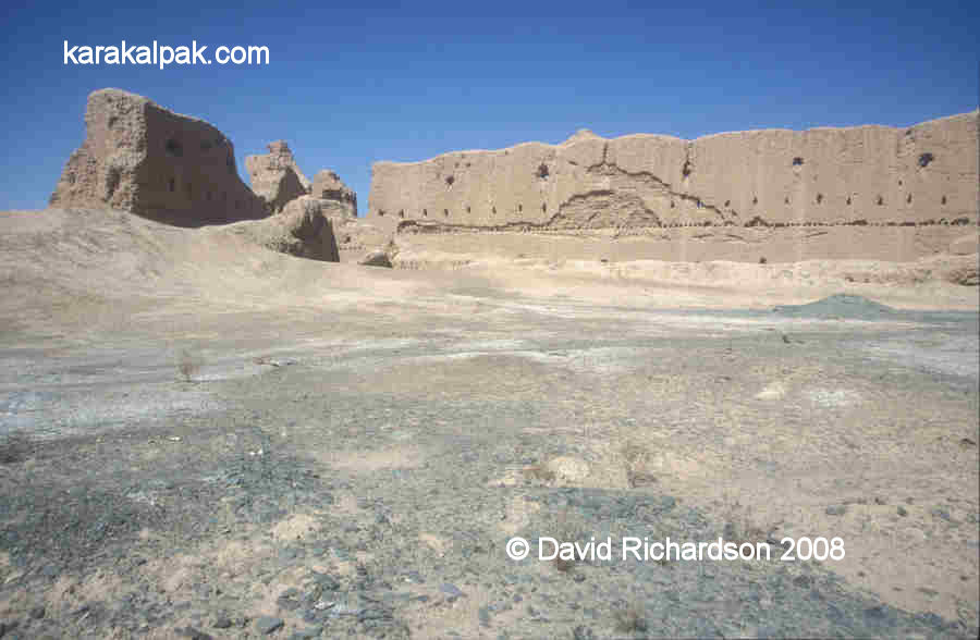
Panorama of the remains of Gyaur qala next to the Amu Darya.
From this point, the road continues straight for a further 4.25km and then bends right, heading due north. After 12.3km from the Badai Tugai junction
there is a metalled side road on the left. Continue along this side road avoiding any further side turns. Some 7.6km from the A380 the road kinks
right and then left before reaching an industrial site. Turn right at the buildings and after a further 1km the ruins of Gyaur qala can be clearly
seen on the left hand side.
Excavations
Gyaur qala was initially investigated briefly by Sergey Tolstov in 1940. More detailed excavations were undertaken by Yuri Rapoport and S. A.
Trudnovskaya in 1952. The Soviet authorities were considering plans to build a hydro-electric plant close to the site and so the Khorezm Expedition
was allocated a detachment of prison labourers to speed up the work. Rapoport and Trudnovskaya's findings were published in Volume 2 of the Works of
the Khorezm Archaeological-Ethnographical Expedition in 1958.
Gyaur qala
The name Gyaur qala probably originates from the time of the Arabs who referred to all non-Muslims as "geburr". Over time the word became
pronounced "gyaur".
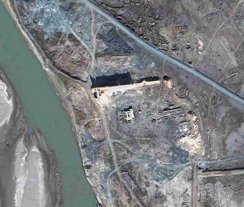
Satellite image of Gyaur qala. Image courtesy of Google Earth.
The buildings just to the south of the wall are modern.
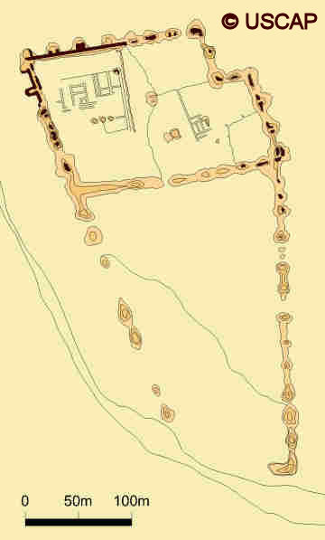
Schematic plan of Gyaur qala.
Image courtesy of Associate Professor Alison Betts, University of Sydney Central Asian Programme.
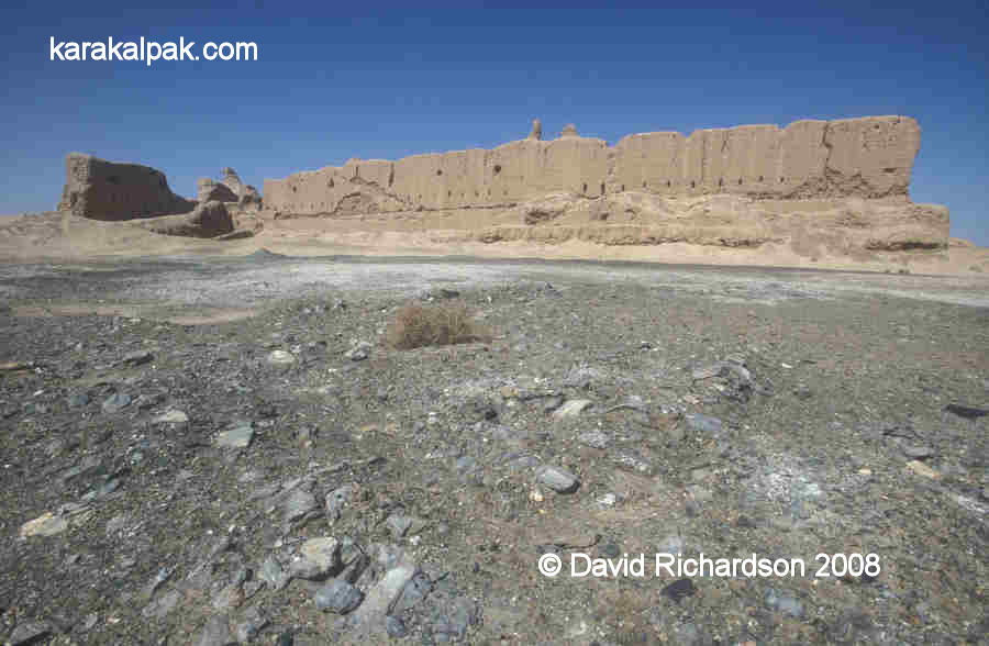
Gyaur qala was a big fort and had an unusual trapezoidal layout. It measured roughly 450 metres from north to south and was roughly 200 metres wide at
the northern end. The site then progressively narrowed to the south, the south-western wall appearing to curve to follow the bank of the river. Today
only the northern wall and part of the north-west corner remains. Even so, the northern wall is preserved in parts up to 15 metres high.
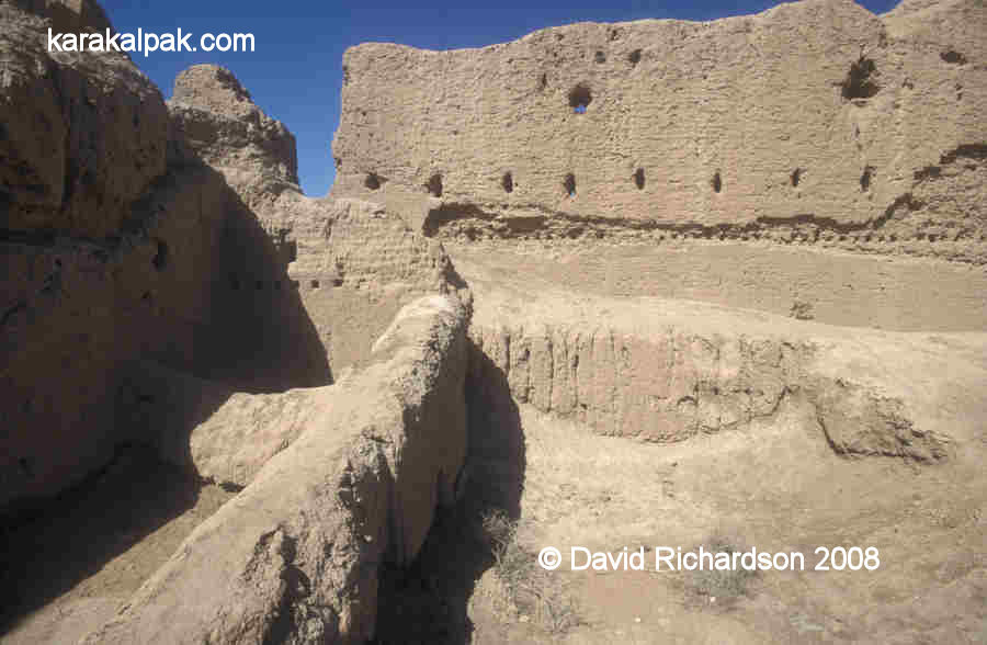
Two views of the north-western corner of the ruins, taken from inside the northern courtyard.
Note the embrasures and the holes for holding the wooden floor beams of the archers' gallery in the bottom picture.
The fort was enclosed with a double mud-brick wall built upon a plinth or socle of compacted clay or paqsa, designed to defend the
lower section of the wall against attack by battering ram. The outer walls contained two tiers of embrasures, the space between the walls being vaulted
to support the upper archers' gallery. The upper archers' gallery was roofed with wooden beams, reeds and clay. At the very top of the wall was an
open topped gallery, protected by battlements. The walls were reinforced with towers along each flank and at each corner, the corner towers arranged
in the early "dove-tail" pattern. The towers had three storeys aligned with the levels within the walls.
Illustration showing the structure of the outer walls and one of the western side towers.
Reconstruction by Yu. A Rapoport and G. S. Kostina.
The space enclosed by the outer walls was separated into two large courtyards by a dividing wall. The southern enclosure was devoid of buildings and
may have been used for billeting mounted troops or for containing temporary dwellings such as yurts. However the northern enclosure contained a
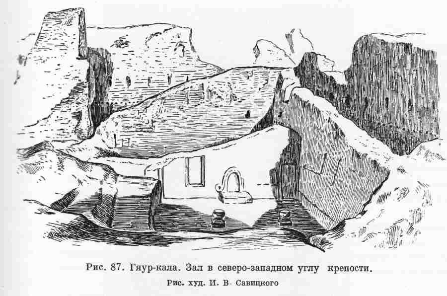
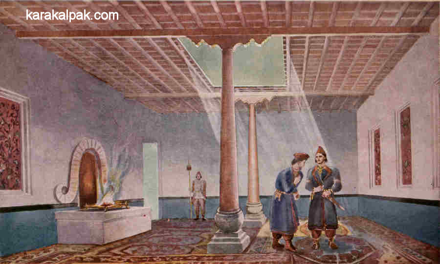
monumental building in its north-western corner. This contained a "guest hall", richly decorated with wall paintings and clay statues. It was
enclosed by a roof supported by wooden columns standing on carved stone pedestals. One of the walls contained what appeared to be the remains of a fire
altar with a prominent decorative ram's horn surround behind it.
Sketch of the excavations of the "guest hall" showing the ram's horn decoration at the back of the fire.
Drawn I. V. Savitsky. Note the stone column bases.
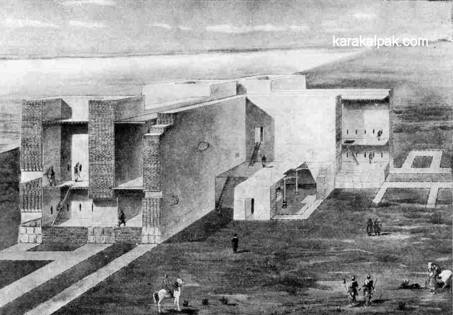
Imaginary reconstruction of the guest hall.
Painting by Yu. A. Rapoport and G. S. Kostina.
The fort appears to have been constructed during the 4th century BC. Its objective was to guard and control the important Amu Darya trade route at it
crossed the southern frontier of Khorezm. It must have been an impressive site when viewed by vessels sailing down the Amu Darya. There is ample evidence
to show that Khorezm was at that time an important stage on a trade route that extended from India in the east, to the Black Sea in the west, and to
Persia and Mesopotamia in the south-west. The fort continued in use until the late Kushan period, around the 3rd century AD, during which modifications
were still being made to the fort.
Google Earth Coordinates
The following reference point (in degrees and digital minutes) will enable you to locate Gyaur qala Sultan Uvays Dag on Google Earth:
| | Google Earth Coordinates |
|---|
| Place | Latitude North | Longitude East |
|---|
| Gyaur qala | 42º 4.840 | 60º 16.555 |
| | | |
Note that these are not GPS measurements taken on the ground.
Visit our sister site www.qaraqalpaq.com, which uses the correct transliteration, Qaraqalpaq, rather than the
Russian transliteration, Karakalpak.
Return to top of page
Home Page
|